Pacific Crest Trail... photos and journal
Summer of 2001...Oregon...
(Page 1 of 4 pages)

Ashland is the first stop in Oregon
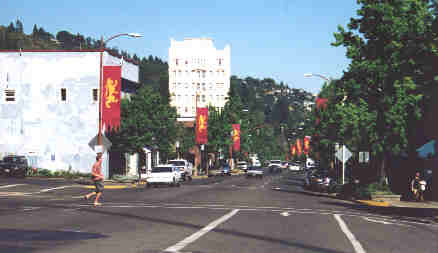
Downtown Ashland.
From my journal (July 12, Day-78)..."It's now only a short walk to the interstate when I cross a sign that says "Callahan's"...1st beer is free, so I immediately walk in that direction until I come to the interstate and walk down to the restaurant at 7:00 am just as the doors are opening. I am greeted with cheer at the front lobby and led to a nice table overlooking the lush green lawn out back then I order a great mushroom omelet and a free cup of coffee since I was a hiker. The owner says that I'm the first thru-hiker of the season to stop in as I'm browsing and signing the PCT register. When I'm done he offers me a ride to the trailhead but I had to go into Ashland for resupply and to send ahead food drops for all of Oregon so after paying I walk up to the on-ramp and catch a ride into town about six miles down the mountain.
I checked into the Columbia Hotel since it was so close to the grocery store and the post office, then I could just catch the bus to the UPS terminal. All day I am committed to getting all my work done and over with so that I can relax so I work fast and hard buying a ton of groceries then preparing three food drop packages for all of Oregon. It was a busy work day in town but it had to be done. "
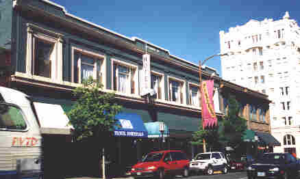
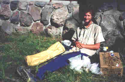
I stayed at the Columbia Hotel (upper part of building) on the first day since it was so perfectly located to a major supermarket and the post office. That was important since I was resupplying as I went and mailing food boxes ahead of myself.
From my journal (July 13, Day-79)..."Eventhough I'm in town I still wake up at first light ready to go. I first walk one of my food drop boxes down to the UPS terminal then mail a couple of packages home, then spend some time with my email at the library. This evening I plan to go out to a movie and just enjoy probably my last major town stop until my hike is done. I also checked into the Ashland Hostel which is a lot less expensive than the hotel! This evening was very relaxing and I enjoyed walking in the park, ordering a new pair of shoes to be sent to Cascade Locks, taking in a movie, then topping it off with a pint of the fatest ice cream that I could find! "
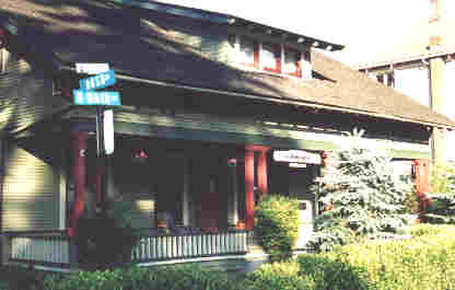
Getting a little better value for my dollar, I stayed at the Ashland Hostel the second day and with my work now done I enjoyed the town and took in a movie too.
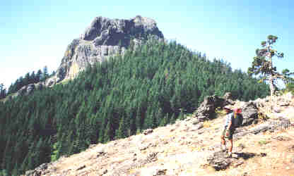
This is Pilot Rock, a very distinct landmark along the trail north of Ashland.
From my journal (July 14, Day-80)..." was the first one to wake up and get moving in a very hot and full room down in the basement of the hostel which I was glad to leave. At 6:00 am I'm walking south across town toward Interstate 5 which is several miles away, but the bus didn't run on Saturday or I could have taken it to the on-ramp. I got a ride in just 10 minutes by a gentleman visiting from Norway and he shortly lets me out at exit #6. Back on the trail I felt free again on a nice forest trail toward Pilot Rock. Seems that most everyone must have got caught up in Ashland because suddenly I feel like I'm hiking in a little time-warp zone with no other thru-hiker within 30 miles of me in either direction. It's sort of a lonely feeling, but also must be approached as an opportunity to think and to reflect without any support. The trail continues to be a fine path for efficiency... mostly just one long roller coaster of a ride with a fine soft tread of pine needles. Couldn't ask for much more. I finally camp atop a summit past the north end of Hyatt Lake where I am constantly attacked by some strange birds until dark. I must be sleeping right on their turf with a nest nearby. "
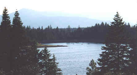
A view of Hyatt Lake as seen from my campsite.
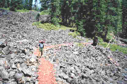
Walking on a volcanic rock trail near Mt. McLoughlin.
From my journal (July 15, Day-81)..." Directly at sunrise the birds get right back to their diving air attacks, but I soon ceed the summit back to them by continuing my hike. I had also been awaken during the night by a mouse which I had to battle in defence of my backpack, but it finally gave up after I kept launching rocks at it's hideout! The trail continued its mostly shady walk all morning interupted once by an ice cooler near one of the roads full with Cokes, left for hikers by someone named Vance. I sign his register and drink the Coke which made the morning so nice with all that wonderful carbonated water bloating my stomach!
Later in the day I begin walking on red lava rock for several miles leading up to Mt. McLoughlin which is a dormant volcano and one of the highest landmarks in southern Oregon according to another hiker. It was a great change in scenery however the very rocky trail was hard on my feet. Past highway 140 I take a break near the creek then pack a liter of water since this is a very dry section. It soon becomes very windy and cold but I push on making it a very long but productive day. "
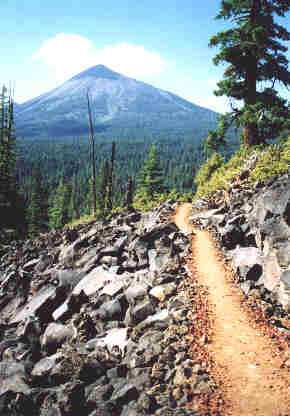 | A very nice view of Mt. McLoughlin as the PCT winds through a lava field and sort of a chilling scene considering that Mt. McLoughlin is a dormant volcano. | .
From my journal (July 16, Day-82)..." The wind from last night died down, but this morning was cold and overcast. Right off I took the wrong trail and had to backtrack about half a mile. Water has been far apart lately, but Christi Spring is flowing strong so I "camel-up" and pack some however not much is needed between water holes when the day is so cool and overcast. From the Devil's Peak area I get some great views of the landscape and could see Mt. McLoughlin and Mt. Shasta... two dormant volcanos in the distance. Looking out over this far and wide landscape I could easily imagine the scene of thousands of years ago with massive smoke and ash filling the sky with clouds ranging in color from purple, red, yellow, and orange... with veins of lava flowing in a myriad of channels off the volcanos into rivers of fire. I would have loved to have seen this but had to settle on my vivid imagination as I walked along this ancient ridge!
Later in the day I was elated to run into Jason, Mike, and Eric... and I hadn't seen Eric since Agua Dulce. I hiked with them for several miles and really enjoyed getting caught up to date with Eric. I ended up walking until dark and camped on a small flat spot just feet from the Crater Lake National Park southern boundary sign. This had been a great day! "
Crater Lake National Park...
I hadn't seen Eric in over a thousand miles, then near Crater Lake he catches up to me. We overlapped each other most of the way to Canada from here and shared quite a few campsites.
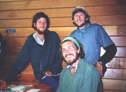
At the Rim Village Cafeteria Mike stayed behind to visit with family and this was the last time I saw him on the hike. (L to R) In the rear is Eric and me, and Mike is seated.
From my journal (July 17, Day-83)..." Two older ladies stopping for photos beside the sign woke me up, then I was on the trail and passed by them within half an hour. And of course I was very excited since I'd anticipated this great lake from the beginning of my hike! I first crashed through the woods then walked the access road a few miles to the post office at the park headquarters building. I could have thumbed a ride but decided not to since there was a trail and I was on an extended alternate route. Just as I'd walked outside with my food drop box here comes Eric who was yelping in high spirits. He had two huge boxes, but sent a lot of it ahead. We spent the next half hour sorting out food in the warm sun, then saw a movie on Crater Lake and then wrote a note for the lady in the post office to attach to Mikes box since he was planning to meet family here tomorrow and we might not see him again. We then crashed through the woods and landed at the lodge where we had a great meal then walked to the Village Rim Store where we ran into Mike. It was nice to see him one last time since we both starteed on the same day at Campo and have been overlapping for 1,800 miles... more so than any other hiker on the trail!
I wished him a farewell, shook hands then began hiking along the west rim of Crater Lake. The trail followed the rim for several miles providing spactacular views of this huge lake that was actually a volcanic mountain before it collapsed back into the earth leaving this magnificent crater. Despite the highway and people this is a walk I wouldn't have missed for the world! The trail eventually tapered away from the crater and aimed toward the parks north boundry where I caught up to Eric and we hiked until dark making camp just outside the parks north boundary. "
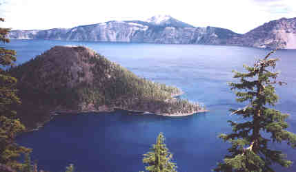
The PCT now follows the west rim of Crater Lake for several miles and as Eric said, "You haven't seen blue until you've seen Crater Lake."
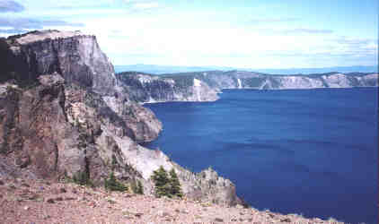
This is near where the PCT finally veers away from Crater Lake.
Join me on the next page as I hike around Mt. Thielson and into the lake country of Oregon.
BACK |
PCT HOME |
NEXT |