Pacific Crest Trail... photos and journal
Summer of 2001...Central California...
(Page 4 of 7 pages)

From my journal (June 8,Day-44)..."Sleep was a bit restless last night due to some late night talkers in the campground and having to adjust to a soft matress. I was up early but the cafe didn't open until 8:00 am so I had to slip back into my bed for a couple of hours until the morning warmed up. We finally go down for breakfast after the generator is cranked up and have such a nice meal, then hang out doing last minute packing and filling our stomachs with plenty of food. About 2:00 pm it was nice to see Galen and Anna hike into the resort and we shared many stories. I was waiting until the last minute to see if my new hiking shoes had come in with days mail. I had explained to Sara that I was expecting them so she called the owner of VVR "Peggy" in town and she made a special trip to the post office for me. At 3:30 pm she drove up and I still had no shoes, but she promised to forward them to me up the trail when they arrived. The folks at VVR really went out of their way to meet my needs which was greatly appreciated. Anyhow, I barely made the 4:00 pm ferry run back to the trailhead along with Mike and Bruce. I really had the momentum and made it over Silver Pass and back down into the trees just at dark. It was nice to be back on the trail making progress once again eventhough Tuolumne Meadows was less than 3 days away! "
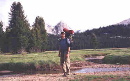
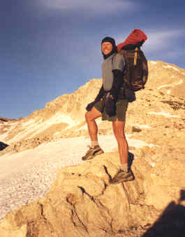 | Very late evening atop Silver Pass. | .
From my journal (June 9,Day-45)..."Early on, hiking was all downhill from Silver Pass, but it wasn't long before I was headed back up another valley passing by Tully Hole then several nice high mountain lakes. Somewhere along the way I met a new thru-hiker named Jason who hiked with me until I stopped to cook some lunch at a good spring. Coming into Reds Meadow the mountains seem to have flattened out for a short while. When I finally reached the junction I decided to walk into Reds Meadow but the cafe wasn't open yet and the man at the store said that he'd only been open for a day since the road here wasn't opened until yesterday. Most of the stock was still in boxes so I got myself a chocolate milk, chips, and an ice cream, then used the telephone outside and finally got back on the trail.
Next I passed through the Devils Postpile National Monument. At some point the PCT and the JMT (John Muir Trail) seperated into different directions. Just past a huge waterfall on Minaret Creek I pull over to cook a meal on a small knoll across the Middle Fork River and the campground which was nice gazing down on all those civilized campers and smelling their grilled food smoking all the air. Back on the trail I soon crossed Mike who was also cooking a hot meal on the side of the trail while fighting off the hordes of mosquittos all the time. I ended up camping just a short distance north on a tall knoll overlooking the rushing creek below. "
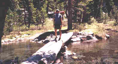
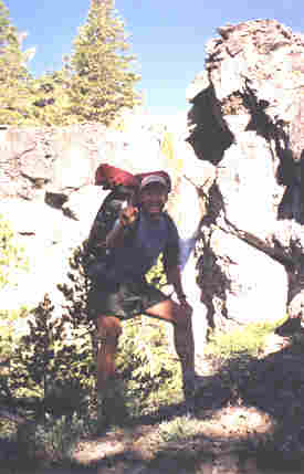
Bridge crossing near Donahue Pass.
From my journal (June 10,Day-46)..."At 6:15 I'm hiking and run into Mikes tent only five minutes up the trail from where I camped and he is still sound asleep so I move on quietly. Later in the day he'd told me that he'd slept in until 9:00 am and really had to steam it over Donohue Pass. It was a really pleasant mornings walk through a quiet campground then into Ansel Adams Wilderness Area and on into Askew Meadows. Several close by deer were grazing about and it was refreshing to see them leap into the next cover of bushes as I walked down the trail. Grom high above there was one gigantic cascading waterfall crashing all the way down the opposite mountainside providing the drainage for a secluded mountain top blue water lake. It was still so loud across the huge valley and I wanted to go there so badly, but no such side trip could be arranged for this trip which was to reach Canada before the first snow flew in September... so I walked on northward.
Both Agnew Pass (9,710) and Island Pass (10,200) could hardly be recognized as passes, except for a slight arc over an otherwise not very obvious hill with trees and patches of lingering snow. Donohue Pass at 11,056 feet would present the more familiar high elevation and snow hidden pass that I had become used to through the Sierra's. It was a long climb up and relatively easy to keep track of the trail since the late spring snow melt seems to be finally taking hold in these mountains, with only spotty patches of snow to navigate and negotiate. The top of the pass was another story with full snow cover but I soon found the trail again after just taking a leap of faith down the snow packed opposite side of the pass where I soon began to discover a maze of trail pieces where the sun was revealing more and more of my trail each day.
Finally down into the trees again it was nice to be in Lyell canyon with its green meadows and such clear water streams which would lead me on to my next resupply point in Tuolumne Meadows. About 7:00 pm Mike had caught up to me and he said that Jason was camped about two miles back. We soon made it to a campsit and rested well through the night. "
Tuolumne Meadows
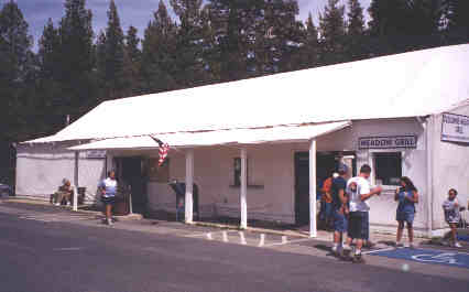
The store at Tuolumne Meadows was one of the best surprises on the trail for me. This big canvas tent had a fairly large grocery store, post offfic, and fast food restaurant. The grocery store had a very good selection of trail type foods and it would have been easy to completely resupply here. Mike, Jason, and I spent the whole day hanging out here, making phone calls, and eating a lot!
From my journal (June 11,Day-47)..."Once again I passed by Mike's tent very early and just down the trail from where I'd been camped... still sound asleep. It was a very easy and level hike down the remainder of Lyell Canyon to Tuolumne Meadows Store and post office where I arrived about 8:00 am. Nothing was open until nine, by which time Mike and Jason had arrived. It was really nice spending the whole day hanging out on the picnic tables out front eating food from the store and grill, watching all the people who were watching us as they passed in and out of the store and all the time packing our packs for the next 151 miles to Echo Lake. The store, post office, and grill were all in what is some kind of huge canvas circus-type tent which was interesting.
About 5:45 pm I became very restless to be back on the trail so I said my goodbyes and got to walking. I left in great spirits knowing that all three of my maildrops had arrived, plus I had mailed my ice ax back home and my pack was now a bit lighter. I was also well rested from lounging and eating all day which made the late afternoon and evening walk most enjoyable. Mike remained behind making an alcohol stove for Bruce who hadn't yet arrived and Jason was still on the phone. Most of the day the sky had been overcast and windy thus making out stay at Tuolomne a bit chilly and as I walked away there appeared to be a very dark thunderhead toward the north which made me walk even faster. The trail basically followed the flow of the Tuolomne River all the way to my campsite at Glen Aulin, sometimes traversing some magnificent sheets and cliffs of smooth solid granite which seems to be one of the most sistinct natural trademarks of Yosemite.
Although I have temporarily lost the PCT during my late arrival in the Glen Aulin area I am sure high in spirits knowing that all of my maildrops had made it to me and that I am now freshly resupplied for another 152 miles to Echo Lake! Good night! "
| I met Jason, a recent graduate of the University of Colorado, the second day after leaving VVR and we overlapped each other all the way into Oregon. Note the wooden handmade flute on his pack that went all the way. |  |
Standing beside the Tuolumne river in a place with almost "magical" quality scenery, like something out of the fantasy land of hobbits rather than just an American wilderness area.
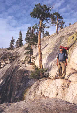 | Huge expanses of solid granite was a common landscape in Yosemite National Park. | .
From my journal (June 12,Day-48)..."First thing this morning I walked back out of the campground retracing my stips back to the Conness Creek Bridge and after studying the trail up that creek, I spotted one of the old original PCT metal trail plaques attached to a tree. That was a great relief so I started hiking due north up a trail that followed Cold Canyon Creek for several miles, through some very tall old growth coniferous forests and at least one rich green wide open meadow. Horses had been through recently which made the loosely turned sand hard to walk. Down in Birginia Canyon I had to cross McCabe Creek and Return Creek, but I managed to find a mostly dry way across both.
At 9,490 feet I paused to grasp the silent beauty of Miller Lake with its almost domesticated beach front appearance. Down in the Matterhorn Canyon I had to ford across the creek there and was a bit upset when I later saw a dry crossing a few hundred yards downstream afterwards. Benson Pass at 10,140 feet was the high point of the day and I stopped for a long break beside the creek on the other side. When I finally popped out of the rocks there was Jason coming down from Benson Pass. We spoke for a moment then I took off in a hurry, anxious to get moving and warm as it was now a very chilly afternoon. I cross the Benson Lake valley very late then climb two to three hundred feet high on the opposite mountainside and made camp there in an open rocky area. "
| Huge trees in Kerrick Canyon at milepost 975.1 that were so magnificent and beautiful that I sometimes became dizzy while concentrating on them! | 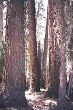 |
From my journal (June 13,Day-49)..."I was climbing first thing this morning to get up and over Seavey Pass (9,150) and it was very chilly so I had just about all of my clothing layers on my body and the sun didn't shine on me until I was over the pass. Just before the pass near one of the small lakes it was nice to walk up on a deer that just froze in its tracks as I passed on by. Kerrick Canyon was a most welcomed walk following the creek from above for several miles... and that is where I found Mike, just on the other side of the creek that he'd just forded across. As I walked up Mike was sitting down with his back to me as I asked, "Well, what are we suppost to do here?" He looked up in surprise to see me, then said that he'd just walked straight across the creek without delay, but I opted to walk across on a log about 40 feet upstream. We walked together for the next couple of miles enjoying the company of each other, since leaving Tuolomne Meadows we haven't crossed a single southbound hiker and you quickly get the feeling that you're the only human around. Gor that reason along with the reality that the thru-hiker crowd has been greatly thinned out by this point in the hike, is why we seem to bounce off each others company.
From Wilmer Lake the trail followed the valley for about seven miles to Dorothy Lake but about half way there I took an hour break beside the stream, napping for 45 minutes and eating for 15. Between a dose of deet, long pants, and a mosquitto net over my head, I was able to fend off the pesky beasts for a while! At 5:00 pm I got moving again feeling very refreshed where at Grace Meadow I ran into Jason who trailed me by about 100 yards all the way to Dorothy Lake Pass where I lost sight of him and where I lost the shoe tracks of Mike. Both must have stopped to camp but I pushed on in high spirits on a very easy downhill trail grom the pass, finally making camp on a small knoll near a creek. This had been a great evening! "
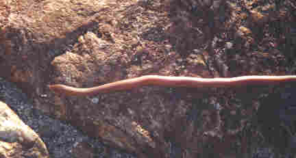
This small red snake (10" long) was crossing the trail near Benson Lake, but I couldn't begin to identify it for you???
From my journal (June 14,Day-50)..."This morning was the coldest in a long time with some ice in my water bag, but I still mustered up the will to get up and moving. Coming up first thing was the crossing of my first one thousand miles on the PCT, marked in the offical Data book as "cross another creek". As insignificant the spot it did lift my spirit to hike the first thousand miles. Finally turning up Kennedy Canyon I had to cross the creek where I slipped on a wet log and got my feet wet first thing, but not even that could get me down knowing that Sonora Pass was up ahead. Up the canyon the trees eventually gave way to the completely wide open space atop the crest, fully exposed to the elements and where the cold wind had me in full winter wear quickly. It was so beautiful as I moved across the crest, having to negotiate many remaining patches of snow. But they were melting fast, most of the day was spent traversing the ridge from one pass to the other side then around to another side making dull moments a rare thing. Half frozen lakes and glaciated mountainsides made the place beautiful byond verbal description. Before mid afternoon I had descended to the actual Sonora Pass at highway 108 where the trail suddenly popped out onto the top hump of the pass. Traffic was very light and I paused for a photo beside the sign.
I then began my climb up the other side of the pass and over to the saddle where another trail led to Wolf Creek Lake and at 10,250 feet elevation. The guidebook also indicated that this would be the last place above 10,000 feet on the PCT north to Canada. A relief in one sense but sad in another.
About 5:00 pm I stop for a 50 minute break to write in my journal and truely savor the moment for myself by brewing a fine cup of coffee. Since probably 95 percent of the daytime is spent hiking, I am working on ways to make my breaks truely quality time which is extremely important when working the body so hard at a constant pace. I continue on down the canyon at a very good pace, then the trail heads up on the ridge again. At about 8:00 pm I stop to fill my one liter bottle at a nice stream where two people are camped then move on to a nice campsit another mile down trail atop some granite boulders. It was a nice and cozy spot! "
 | I have one finger up in the air signifying the point on the trail of my first 1,000 miles. | .
Join me on the next page as I hike through Sonora Pass.
BACK |
PCT HOME |
NEXT |