Pacific Crest Trail... photos and journal
Summer of 2001... The Desert continued...
(Page 4 of 10 pages)

| Here the PCT enters some beautiful and spacious grasslands a few miles past Barrel springs and just before Warner Springs. Fortunately there was a trail marking post here, but for the most part in places like this I just had to engage my good sense of direction, then took a leap of faith... which kept me "un-lost" 99 percent of the time! | 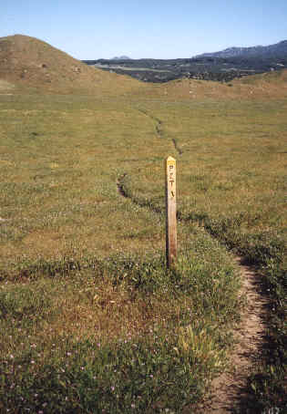 |
From my journal(May 2, Day-7)..."Wind blew with a vengeance all night long flapping my plastic ground cloth to no end. At times I'd wake up thinking all my gear had blown away so rest came sporadically. It was about 6 miles down hill to a barely flowing Barrell Springs which marked the end of one long waterless section. From here it was hiking in the grasslands which was a much more moist environment than the full desert
Finally to Warner Springs I spent 2 hours in town with my drift box then shipped it on to Big Bear City, while all the time constantly talking to other hiker's outside the post office. After calling home and having a good meal at the Golf Grill with "Grizzly", "Wolfdog", and another couple I headed back to the trail anxious to keep moving north and where the trail was all uphill but following through a more moist environment. Just at dark and at the end of Lost Valley Road I find a campsite snuggly set in some granite boulders."
Town of Warner Springs
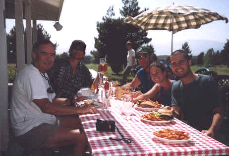
At the Golf Grill in Warner Springs (left to right) it's Wolf Dog from Dothan, Alabama, me, Grizzly from Kentucky, and a newlywed couple whose names I'm not certain. After Lake Morena, this was my first official maildrop town. I spent about 45 minutes at the post offfice packing up, made a phone call home, then spent the remaining time at the Golf Grill drinking iced tea and doing some serious munching on burgers n' fries. I was in and out of town in under two hours.
The San Jacinto Mountains
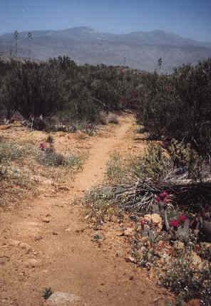 | North of Warner Springs the San Jacinto mountains are the highlight and the scenery is great. Here is a dry desert section looking ahead to the cooler mountains to come. | .
From my journal(May 3, Day-8)..."Once again the wind blew strong all through the night and even the granite boulders and high chapparal couldn't stop all the commotion. Today I only saw one person so it was sorta lonely. The trail was very rocky and not good on the feet. At Tule Spring I walked a half mile off trail for water which was a royal pain taking five liters. Less than half a mile I dumped two and a half liters of the precious liquid and just prayed that the creek ahead in Nance Canyon was running... and it was, if only a mere trickle.
Late in the day I was looking for a flat spot to camp in Alkali Wash (a big canyon) when I fell down head over heal on a small dry bank then into some brush. Fortunately, only my left leg had several small cuts, but from the streaming of blood down my leg made it look much worse than it was. Not finding a campsite here I walked out of the canyon until I found a decent spot in the thick bushes atop a chaparral ridge. "
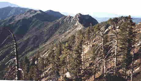
The trail followed this ridge on to Idyylwild and eventually I even lost the trail briefly in places where the snow still lingered.
From my journal(May 4, Day-9)..."While packing this morning I broke the cheap zipper on my fanny pack which had been shifting some of my backpack's weight to my hips, so it wasn't a good start. After crossing the pines-to-palms highway 74 it was a long days climb into the hight San Jacinto mountains. I first hiked by a lot of granite boulders then it was true ridgeline hiking on the crest. At Live Oak Spring I made a wrong turn which cost me a half mile so I've become much more aware to guide and map.I am also running very low on food so I've had to make some big miles today which is taking a toll on my body so early in the hike. Finally I found a well hidden campsite on a very scenic overlook, however when I took off my left shoe I realied that the pain I'd been feeling was coming from a swollen ankle. I took 600mg of Ibufrofen and hoped that this wasn't the end of my trek! "
Town of Idyylwild
| This is J.D. who is a film major at UCLA and thru-hiked the PCT in 2000. He had interviewed me at the Kick-off at Lake Morena and here he was in Idyywild looking for hikers. We spent several hours having a great talk, then he drove me back to the trailhead. You can visit his website at Journey Film.com | 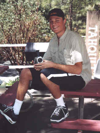 |
From my journal(May 5, Day-10)..."At wake up I'm so thankful that my ankle feels a hundred percent better and is now just a bit tender. I hike north so happy to be okay and headed toward town. Sleep was so sound with the wind so still and I can only recall pleasant dreams having been in the serenity of my sleeping bag for eleven hours in the best campsite yet, situated near the edge of a steep ledge overlooking the great beyond. It was 5.8 miles on a trail that was mostly covered with snow where on a few occasions I lost the trail completely, but always located one central and dominant landmark as I searched for the path which I always found.
At Saddle Junction I hike down 2.5 miles on a steep trail, then a man in a small sports car takes me two miles into town after reaching the paved road. I got a fine room at the Tahquitz Inn where the manager "Bob" gave me rides around town and offered to take me back to the trailhead when I'm ready to go. After a shower I bought groceries and had a great lunch at Jan's Red Kettle. I bought a new heavier fanny pack and replaced a worn out silk shirt with a good polyester shirt while shopping at the outdoor store and also where I ran into Larry (G.T.) who was having a waist belt made for his backpack. It's been a good day and I can only pray that my ankle has healed enough to hike by tomorrow. "
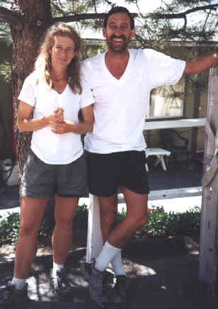 | This is Tim & Ann Umstead "The Raven's" who thru-hiked the PCT in '96 and had returned to the trail this year, hiking from the border to Big Bear reliving old trail memories. I first ran into them in the hot San Filipie Hills while crouched up in the tiny shade of a bush. They were the first to inform me that before I got out of the desert that chapporal would become my friend, for shade that is. We shared a lot of great stories, especially in Idyylwild where I had a room at the Tahquitz Motel next to theirs. Sure wish they could have stayed on the trail but I was grateful for all they shared about what to expect up ahead. | .
| Here I am looking for the trail along Fuller Ridge where in 2001 the desert mountains got more snow than the High Sierra. I was hiking with "Road Runner" this day and we eventually had to camp right on the trail along the ridge in a small snow-free spot. | 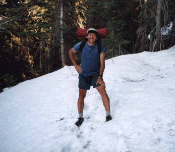 |
From my journal(May 6, Day-11)..."Stayed in the motel room until late morning continously eating a steady stream of rood including an apple, orange, raw broccoli and carrots, plus a lot of coffee! My ankle seems not swollen at all however there is still some tenderness which concerns me since I must pack five days food upon leaving Idyllwild. This is also the main reason that I'm looking at getting back on the trail after noon which should ensure a lower mileage day. I also came into town two days ahead of schedule so this will also get me more in line with reaching Kennedy Meadows when snowpack is less. Above all it is my tender ankle which concerns me the most.
Finally about 10:00 a.m. the "Ravens" who were in the room next to me visited and for the next two hours we had a good conversation about the trail ahead then they helped me with a few new ideas about lowering my pack weight even more. At some point "J.B." who had been at the Kick-off drove up having driven from LA looking for hiker's to interview for his journey film project at school. About noon he drove me back to the trailhead where he continued to interview and film me. At the trailhead parking lot there were a lot of Sunday afternoon hikers out and I sat on a downed log to eat a tub of potato salad before the 2.5 mile ascent back to the PCT. I was to the top in an hour where I met a section hiker named Roadrunner and we hiked together for ten miles through a lot of snow to finally camp directly on the trail near the end of a very snowy Guller Ridge . "
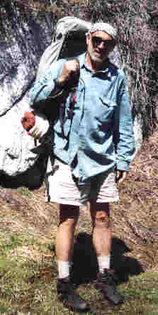 | I hiked with "Road Runner" along Fuller Ridge. He was certainly an interesting fellow who loved the trail, but his method of hiking was one of the most self sufficent ideas I'd seen. He would park his car at the start of one section after having hid his motorcycle in the bushes at the other end. When completing that section he'd just ride his motorcycle back to his car, then repeat the process. I never saw him again after San Gorgonio Pass but was glad to have shared a camp with him on Fuller Ridge. | .
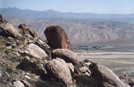
Here is a magnificent view looking out over the hot and parched San Gorgonio Pass just after leaving the snowbound Fuller Ridge behind. This was a typical example of hiking through the southern California desert... at one moment you would be trying to find the trail through the snow, then the next you'd be parching in the dry sand. The high mountain chains seperating the dry desert crossings quickly became my most anticipated friend!
Join me on the next page as I pass through the scorching desert of San Gorgonio Pass then on to Big Bear City.
BACK |
PCT HOME |
NEXT |